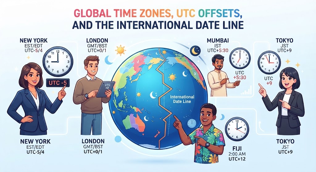
Time is one of the most fundamental yet artificial frameworks governing human civilization. In the pre-industrial world, human settlements lived by local solar time: midday occurred when the sun reached its highest zenith in the local sky (solar noon). However, the nineteenth-century advent of the steam locomotive, electric telegraph, and global maritime networks made local solar time unmanageable. If every town set its station clocks to its own solar noon, railway schedules descended into lethal chaos. To resolve this logistical crisis, the international community engineered the global time zone system—a coordinated spatial grid partitioning the 360 degrees of the Earth’s circumference into standardized 24-hour longitudinal belts.
The Mathematical Foundation: 360 Degrees and 24 Hours
Because the Earth completes one full 360-degree axial rotation approximately every 24 hours (a solar day), the planet rotates through 15 degrees of longitude every single hour (360° ÷ 24 = 15°). In an idealized geographic model, the globe is divided into 24 uniform time zones, each exactly 15 degrees of longitude in width, centered on standard meridians that are exact multiples of 15° (e.g., 0°, 15°, 30°, 45°, etc.).
However, the real-world map of time zones is anything but uniform. Time zones are political and commercial boundaries rather than pure lines of longitude. Governments deliberately contort, bend, expand, and compress time zone boundaries to align with national borders, provincial administrative limits, internal trade routes, and geopolitical alliances.
| Country / Territory | Number of Time Zones | Span of UTC Offsets | Key Administrative Rationale |
|---|---|---|---|
| France | 12 (13 including Antarctica) | UTC-10 to UTC+12 | Vast legacy of overseas departments and territories across Pacific, Indian, and Atlantic oceans. |
| Russia | 11 | UTC+2 to UTC+12 | Enormous terrestrial landmass spanning 170 degrees of longitude from Kaliningrad to Chukotka. |
| United States | 11 (including territories) | UTC-12 to UTC+10 | Continental states (4 zones) plus Alaska, Hawaii, and overseas island territories. |
| Australia | 3 (mainland standard) | UTC+8 to UTC+10.5 | Divided along state borders, with non-standard half-hour offsets in South Australia and NT. |
| China | 1 (official national) | UTC+8 (Beijing Time) | Enforces political unity across a geographic landmass naturally spanning five longitudinal zones. |
| India | 1 (official national) | UTC+5:30 (IST) | Compromise median meridian (82.5° E) passing through Mirzapur, Uttar Pradesh. |
From GMT to UTC: The Evolution of Universal Time
At the 1884 International Meridian Conference held in Washington, D.C., 25 nations voted to establish the Prime Meridian passing through the Royal Observatory in Greenwich, London, as the initial meridian for longitude and time calculation. This established Greenwich Mean Time (GMT) as the international reference standard, based on the mean solar time calculated at the Greenwich meridian (0° longitude).
In the mid-twentieth century, the development of ultra-precise atomic clocks revealed that the Earth’s rotational speed is irregular and gradually decelerating due to tidal friction. In 1972, the international scientific community replaced GMT with Coordinated Universal Time (UTC). UTC is maintained by the International Bureau of Weights and Measures (BIPM) using an ensemble of hundreds of atomic clocks, kept synchronized with astronomical solar time through the periodic insertion of “leap seconds.”
The International Date Line: Tearing the Calendar
Directly opposite the Prime Meridian on the other side of the planet lies the 180th meridian, running through the Pacific Ocean. This longitudinal line forms the basis of the International Date Line (IDL). Crossing the date line alters the calendar day: traveling westward across the line adds 24 hours (advancing one calendar day), while traveling eastward subtracts 24 hours (stepping back into yesterday).
The Great Zig-Zags: Kiribati and Samoa
The International Date Line is not a straight meridian; it zig-zags dramatically across the Pacific to prevent island nations from being partitioned across two different days:
Kiribati (1995): Prior to 1995, the sprawling island nation of Kiribati was bisected by the IDL, leaving its western Gilbert Islands on Monday while its eastern Line Islands were on Sunday. Government offices could only communicate on business matters four days per week. In 1995, Kiribati unilaterally pushed the date line thousands of kilometers eastward around its easternmost islands, creating the extraordinary UTC+13 and UTC+14 time zones. Consequently, Kiribati’s Millennium Island is the first inhabited landmass on Earth to welcome each new calendar year.
Samoa (2011): In December 2011, the island nation of Samoa hopped across the International Date Line by erasing December 30 entirely from its calendar, moving from UTC-11 to UTC+13. The rationale was purely economic: Samoa conducts the vast majority of its trade with Australia, New Zealand, and East Asia. Being 21 hours behind Sydney meant Samoa lost two full working days per week in commercial interactions with its primary trading partners.
Fractional and Non-Standard Time Zones
While most time zones adhere to whole-hour offsets relative to UTC, several nations have implemented non-standard 30-minute and 45-minute fractional offsets to better align their civil clocks with the solar meridian running through their territorial center:
India & Sri Lanka (UTC+5:30): India selected 82.5° East longitude—passing through Mirzapur near Prayagraj—as its central standard meridian, yielding an exact offset of 5 hours and 30 minutes ahead of UTC. This half-hour standard prevents the subcontinental landmass from being divided into two distinct zones.
Nepal (UTC+5:45): In 1986, Nepal adopted UTC+5:45, setting its standard time to the meridian passing through Mount Gauri Sankar (86° 15′ E), making it one of only three territories (along with the Chatham Islands and parts of Western Australia) to use a 45-minute fractional offset.
Australia (Central Standard Time, UTC+9:30): The states of South Australia and the Northern Territory maintain a half-hour offset between Western Australia (UTC+8) and the eastern states (UTC+10), maintaining a compromise between economic ties with Sydney and local solar reality.
Frequently Asked Questions About Time Zones
What time zone is used in Antarctica?
Because all longitudinal meridians converge at the South Pole, Antarctica technically occupies every time zone simultaneously. In practice, scientific research stations utilize the time zone of their primary supply hub or home nation: McMurdo Station (US) uses New Zealand time (UTC+12/+13), Amundsen-Scott South Pole Station uses New Zealand time, and Palmer Station uses Chile time (UTC-3).
What is the purpose of Daylight Saving Time (DST)?
Daylight Saving Time is the seasonal practice of advancing clocks forward by one hour during spring and summer months to extend evening daylight and theoretically reduce energy consumption. However, its modern utility is heavily debated, and tropical equatorial nations almost never use DST because seasonal variations in day length are minimal near the equator.
Where can you step across a time zone border with a 3.5-hour jump?
The border between Afghanistan (UTC+4:30) and China (UTC+8) along the narrow, remote Wakhan Corridor represents the largest single official terrestrial time zone leap in the world: crossing this mountain pass instantaneously shifts clocks by 3.5 hours.