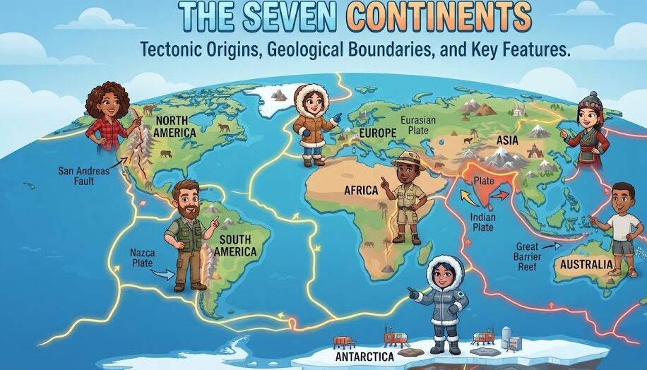
The division of planet Earth’s land surface into distinct continents is one of the foundational conventions of global geography. Yet beneath this seemingly elementary classification lies a complex interplay of deep-time plate tectonics, continental crustal composition, shifting sea levels, and historical human geopolitics. While educational systems across the English-speaking world predominantly teach a seven-continent model (Asia, Africa, North America, South America, Antarctica, Europe, and Australia/Oceania), other cultures teach six-continent models (combining Eurasia or the Americas) or even four-continent models based strictly on contiguous landmasses separated by oceans.
Tectonic Genesis: From Rodinia to Pangaea and Beyond
Continents are not static, permanent landforms; they are buoyant slabs of continental lithosphere (primarily granitic rock with an average density of 2.7 g/cm³) floating atop the denser, ductile asthenosphere. Over hundreds of millions of years, the convective heat engines of Earth’s mantle drive the supercontinent cycle (also known as the Wilson Cycle), continually assembling and fracturing global landmasses.
Approximately 335 million years ago, the major continental cratons collided to form the supercontinent Pangaea, surrounded by the superocean Panthalassa. Around 175 million years ago during the Jurassic period, Pangaea began rifting apart along the Central Atlantic magmatic rift, separating into two colossal landmasses: Laurasia in the northern hemisphere (encompassing modern North America, Europe, and Asia) and Gondwana in the southern hemisphere (comprising South America, Africa, India, Australia, and Antarctica). Over subsequent epochs, continuous seafloor spreading along oceanic mid-ocean ridges drove these fragments into their contemporary geographical configurations.
| Continent | Land Area (km²) | Approx. % of Land | Highest Elevation | Lowest Point | Sovereign States |
|---|---|---|---|---|---|
| Asia | 44,579,000 | 29.8% | Mt. Everest (8,848.86 m) | Dead Sea (-430 m) | 49 |
| Africa | 30,370,000 | 20.4% | Mt. Kilimanjaro (5,895 m) | Lake Assal (-155 m) | 54 |
| North America | 24,709,000 | 16.5% | Denali (6,190 m) | Death Valley (-86 m) | 23 |
| South America | 17,840,000 | 12.0% | Aconcagua (6,961 m) | Laguna del Carbón (-105 m) | 12 |
| Antarctica | 14,200,000 | 9.5% | Vinson Massif (4,892 m) | Deep Lake (-50 m) | 0 (Treaty system) |
| Europe | 10,180,000 | 6.8% | Mt. Elbrus (5,642 m) | Caspian Sea shore (-28 m) | 44 |
| Australia / Oceania | 8,600,000 | 5.8% | Puncak Jaya (4,884 m) | Lake Eyre (-15 m) | 14 |
The Eurasia Boundary: The Great Continental Arbitrary
From a purely physical and geological standpoint, Europe and Asia form a single, contiguous continental landmass sharing the unified Eurasian tectonic plate. There is no intervening ocean, rift zone, or subduction boundary separating them. The division between Europe and Asia is fundamentally a historical, cultural, and political construct originating with ancient Greek navigators who classified lands west of the Aegean Sea and Bosporus as Europa and lands to the east as Asia.
In the eighteenth century, Russian geographer Philip Johan von Strahlenberg and statesman Vasily Tatishchev proposed the modern conventional boundary to align with the expansion of the Russian Empire. Today, international cartographers define the boundary along the Ural Mountains, the Ural River, the Caspian Sea, the Greater Caucasus crest, the Black Sea, and the Turkish Straits (Bosporus and Dardanelles). Consequently, nations like Russia and Turkey are recognized as transcontinental states straddling both continents.
Continental Deep-Dives: Geological and Geographic Character
1. Asia: The Continental Giant
Encompassing nearly 30% of the planet’s total land area and home to approximately 60% of humanity, Asia contains the extremes of terrestrial geography. It hosts the world’s highest point (Mount Everest at 8,848.86 m) and its lowest exposed dry land (the Dead Sea shore at -430 m). The continent is anchored by ancient Archean shields in Siberia and the Indian Deccan, bordered by massive young orogenic belts like the Himalayas, Karakoram, and Tian Shan, and bounded along its eastern margin by explosive subduction arcs in Indonesia, the Philippines, and Japan.
2. Africa: The Ancient Plateau Continent
Africa is characterized by an absence of long, continuous fold mountain chains like the Andes or Rockies. Instead, it functions as a massive, elevated plateau composed of ancient Precambrian crystalline basement shields. In East Africa, an active tectonic rift—the East African Rift System (EARS)—is systematically tearing the continent apart. Stretching from the Afar Depression southward through Kenya and Tanzania, this divergent boundary is creating deep tectonic rift lakes (Lake Tanganyika, Lake Malawi) and active volcanoes (Kilimanjaro, Ol Doinyo Lengai), which will eventually form a new ocean basin tens of millions of years in the future.
3. The Americas: The Cordilleran Spine
North and South America are linked by the narrow Isthmus of Panama, which formed approximately 3 million years ago, triggering the Great American Biotic Interchange and altering Atlantic oceanic circulation (spurring the Gulf Stream). Both continents share a common structural pattern: a colossal active mountain chain along the western Pacific margin (the North American Cordillera and the Andes), vast interior lowland river drainage basins (Mississippi-Missouri, Amazon, and Paraná-Paraguay), and heavily eroded ancient crystalline uplands in the east (Appalachians, Guiana Shield, and Brazilian Highlands).
4. Antarctica: The Polar Ice Shield
Covering the South Pole, Antarctica is the coldest, driest, windiest, and highest average elevation continent on Earth. Over 98% of its landmass is buried beneath an ice sheet with an average thickness of 1.9 kilometers (6,200 feet), containing roughly 70% of the world’s fresh water. Structurally, the continent is divided by the Transantarctic Mountains into East Antarctica (an ancient stable craton) and West Antarctica (a volatile mosaic of rift basins and volcanic islands beneath sea level).
5. Australia / Oceania: The Island Continent
Australia is the world’s flattest, lowest, and driest inhabited continent, devoid of active volcanism or recent mountain-building events. It has remained largely tectonically quiescent for hundreds of millions of years, resulting in deeply weathered, nutrient-poor soils and unique marsupial evolutionary lineages. In geopolitical and human geography, it is often grouped with New Zealand and the thousands of Pacific island archipelagos across Melanesia, Micronesia, and Polynesia to form Oceania.
Frequently Asked Questions About the Continents
Why is Europe considered a separate continent from Asia?
Geologically, Europe is a large western peninsula of the Eurasian landmass. It is categorized as a separate continent due to deep-seated historical, linguistic, cultural, and political conventions established in Western civilization dating back to classical antiquity.
What is the lowest continental point on Earth?
The lowest natural dry-land elevation on Earth is the shoreline of the Dead Sea, bordering Israel, the West Bank, and Jordan, sitting at approximately 430 meters (1,410 feet) below sea level. If including ice-covered bedrock, the Bentley Subglacial Trench in Antarctica reaches 2,555 meters below sea level.
Will the continents ever reform into a single supercontinent?
Yes. Plate tectonic modeling indicates that in approximately 250 million years, the ongoing closure of the Atlantic or Pacific oceans will bring the dispersed continental landmasses back together into a unified supercontinent, commonly dubbed “Pangaea Ultima” or “Amasia.”